


Series
Wadi Zered


Geographical elements in biblical stories are easy to gloss over, because they are mostly unfamiliar to us and seem of secondary importance.[1] Nevertheless, the meaning of a text can change depending on the identification of the geographical markers. This is the case with Nachal Zered mentioned four times in the Torah, once in Numbers and three times in Deuteronomy.
The Hebrew נחל can refer to a regular stream, but also to a dry ravine or streambed, which fills with water only during heavy rains; the closest approximation is the Arabic term wadi. The name Zered means “lush”[2] so the toponym Nachal Zered refers to a verdant stream or streambed.
Zered in Numbers
Israel travels north through the Transjordan, passing through the Moabite wilderness to the Zered Stream.
במדבר כא:יא ... בַּמִּדְבָּר אֲשֶׁר עַל פְּנֵי מוֹאָב מִמִּזְרַח הַשָּׁמֶשׁ. כא:יב מִשָּׁם נָסָעוּ וַיַּחֲנוּ בְּנַחַל זָרֶד.
Num 21:11 …In the wilderness bordering on Moab to the east. 21:12 From there they set out and encamped at the Zered Stream.
They continue to travel, and end up north of the Arnon:
כא:יג מִשָּׁם נָסָעוּ וַיַּחֲנוּ מֵעֵבֶר אַרְנוֹן אֲשֶׁר בַּמִּדְבָּר הַיֹּצֵא מִגְּבוּל הָאֱמֹרִי כִּי אַרְנוֹן גְּבוּל מוֹאָב בֵּין מוֹאָב וּבֵין הָאֱמֹרִי.
21:13 From there they set out and encamped beyond the Arnon [Stream], that is, in the wilderness that extends from the territory of the Amorites. For the Arnon is the boundary of Moab, between Moab and the Amorites.
The Israelites encamp מעבר “on the other side” of the Arnon, i.e., on its north, implying they did not need to cross it.
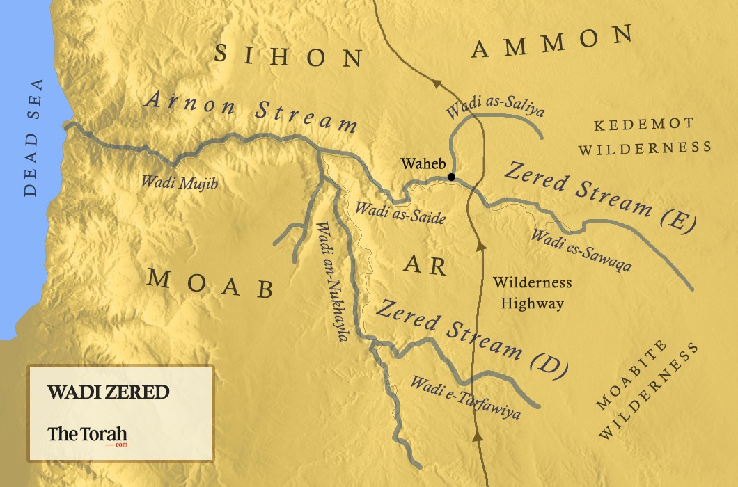
Scholars have long identified the Arnon as Wadi el-Mujib, which runs east-to-west into the Dead Sea. Its western part forms a canyon banked with high cliffs; the central part is similar, with a deep gorge with steep banks, while its eastern part is a shallow valley banked with low, soft, roundish hills.
In modern times, each part of the wadi has its own name. The western part is el-Mujib, the central part es-Saide and the eastern part is es-Sawaqa. I suggest identifying the Zered stream with this shallow eastern part of the wadi, and the Arnon with the deeper, western parts or as a general name for the whole length of the wadi.
Years ago, at the very spot where Wadi es-Sawaqa changes its nature from valley to the gorge es-Saide, I discovered a Roman road, which almost certainly runs over the same spot as the biblical דרך המדבר, Wilderness Road, before it.[3] This would be the natural spot for anyone heading north in this region to cross; certainly, it would be a much easier crossing point than those further west.
As the Israelites are travelling on the Wilderness Road, they camp next to the crossing point of Zered. After they cross, they turn northwest toward Yahatz, and thus, the next camp was already beyond the gorge, on the northern side of the Arnon. (See map.)
Tannaitic Tradition
The description of Israel’s borders in rabbinic literature also understands the Zered Stream as Wadi es-Sawaqa. Defining biblical Israel’s borders was a significant issue for the rabbis, since certain halakhot are applicable only in the land; a detailed list of the borders appears in the Tosefta (Sheviʿit 4:11), in Sifrei Deuteronomy (§51), in the Jerusalem Talmud (Sheviʿit 6:1; 16a), and even on a mosaic floor from a synagogue in the Beth-shean Valley.[4]
One of the toponyms included in this list is the Zered Stream, נחלה דזרד in Aramaic. The inclusion of the Zered Stream as a border of Israel means that the stream cannot be south of the Arnon River, since, as quoted above, the Torah is explicit that the Arnon is Israel’s southern border. Thus, the Zered Stream must be the eastern tributary of the Arnon here as well.
Deuteronomy’s Two Crossings
Deuteronomy also describes Israel’s journey north through the Transjordan. After leaving the Sons of Esau who live in Seir, the Israelites travel north through Moabite Wilderness Road (וַנַּעֲבֹר דֶּרֶךְ מִדְבַּר מוֹאָב, 2:8). As they approach the land of Ar, the eastern Moabite province,[5] God warns them not to harm the inhabitants in any way (2:9),[6] and instructs them to cross the Zered Stream:
דברים ב:יג עַתָּה קֻמוּ וְעִבְרוּ לָכֶם אֶת נַחַל זָרֶד וַנַּעֲבֹר אֶת נַחַל זָרֶד.
Deut 2:13 Up now! Cross the Zered Stream! So we crossed the Zered Stream.[7]
The Israelites enter the territory of Ar-Moab by crossing the Zered Stream. But Ar-Moab is south of the Arnon and its tributaries. Thus, Zered here in Deuteronomy cannot be Wadi es-Sawaqa.
Deuteronomy’s description of Israel’s next step on their journey, when they are about to leave Ar, confirms that Israel is still south of the Arnon:
דברים ב:יז וַיְדַבֵּר יְ־הוָה אֵלַי לֵאמֹר. ב:יח אַתָּה עֹבֵר הַיּוֹם אֶת גְּבוּל מוֹאָב אֶת עָר. ב:יט וְקָרַבְתָּ מוּל בְּנֵי עַמּוֹן...[8] ב:כד קוּמוּ סְּעוּ וְעִבְרוּ אֶת נַחַל אַרְנֹן רְאֵה נָתַתִּי בְיָדְךָ אֶת סִיחֹן מֶלֶךְ חֶשְׁבּוֹן הָאֱמֹרִי וְאֶת אַרְצוֹ הָחֵל רָשׁ וְהִתְגָּר בּוֹ מִלְחָמָה.
Deut 2:17 YHWH spoke to me, saying: 2:18 You are now passing through the territory of Moab, through Ar. 2:19 You will then be close to the Ammonites… 2:24 Up! Set out across the Arnon Stream! See, I give into your power Sihon the Amorite, king of Heshbon, and his land. Begin the occupation: engage him in battle.
Upon leaving Moabite Ar and entering the land to its north, the Israelites must cross the Arnon Stream. In other words, unlike Numbers, Deuteronomy has two crossings, the Zered Stream before entering Ar, and the Arnon Stream upon leaving it. What, then, according to Deuteronomy, is the Zered Stream?
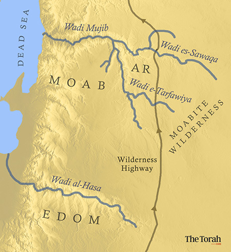
Wadi al-Hasa: The Scholarly Consensus
In 1841, the American Bible scholar and geographer, Edward Robinson (1794–1863), suggested identifying Zered with Wadi al-Hasa, on the southern border of Moab.[9] This suggestion met with wide acceptance then, and remains the standard interpretation even today.[10] Geographically speaking, the suggestion is attractive, since both Wadi Mujib and Wadi al-Hasa are deep gorges that serve as clear geographical borders for Moab.
Support from the Madaba Map?
To strengthen that identification, scholars point to the 6th century C.E. Madaba map, discovered in Saint George Church in Madaba, Jordan,[11] which presents a gorge with a stream pouring its water to the southern side of the Dead Sea (i.e., Wadi al-Hasa). That gorge has a label in Greek that many scholars understand to refer to Zered.
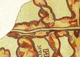
The final letter is either a delta (Δ) or an alpha (A) . Thus, we have either: “ared” or “area.” Many scholars suggest that before the alpha was another letter, and that this would have been a zeta (Z), and the last should be read as a delta, yielding Zared.
But this claim is problematic. First, it is unclear if there ever was a letter before the alpha. (The space before the alpha is sufficiently large to imply there was not.) Moreover, the final letter, though it could be a delta, looks more like the other alphas on the map .[12] Thus, on epigraphic grounds alone, alpha is the better choice.
The publishers of the map decided to read delta, because they already accepted Robinson’s identification of the Zered Stream with Wadi al-Hasa. We have here a perfect circular argument: the map should say Zered as it is the biblical name of wadi al-Hasa and that wadi should be Zered as it says so in the Madaba map.
The Moabite Wilderness Problem
Robinson’s suggestion that Zered is al-Hasa is attractive because it is a large gorge, which would be notable as a border and as an itinerary point. But according to the biblical text, the Israelites are traveling far to the east, along the Wilderness Road,[13] and this part of Wadi al-Hasa is quite shallow and is no more notable than any other streams in this part of the Transjordan.
More importantly, Robinson’s identification actually contradicts the biblical text. According to both Deuteronomy and Numbers, the Israelites are already in the Moabite Wilderness when they cross the Zered Stream. But the Moabite Wilderness is north of Wadi al-Hasa. Thus, for Deuteronomy, we need to be looking for a stream that is north of Wadi al-Hasa but south of Wadi es-Sawaqa.
Wadi e-Tarfawiya
In his posthumously published geographic encyclopedia (1923), Israel Horowitz (1880–1918), a rabbi and geographer who died tragically young towards the end of WWI, identified the Zered Stream with Wadi e-Tarfawiyya.[14] This stream marks the southern border of the land of Ar, south of which is the Moabite Wilderness. It thus fits with the placement of the Zered Stream in Deuteronomy. To support his suggestion, Horowitz pointed to Targum Pseudo-Jonathan on Deuteronomy 2:13, which translates Zered Stream as Tarvayya Stream (נַחַל טַרְוַויָא).[15]
D’s Need for Another Crossing
Why does Deuteronomy move Zered south and add it as an extra crossing? It appears that Deuteronomy is using geographically oriented markers, and the root ע.ב.ר “cross,” to ground each of God’s commands throughout Israel’s journey north:
“Crossing Esau’s border”—Seir Speech: When Israel is traveling through the territory of the sons of Esau, YHWH notes that they are about to cross the border, and commands them not to molest the sons of Esau in any way, since YHWH has given them Seir as their inheritance (Deut 2:3–7).[16]
“Cross the Zered”—Ar-Moab Speech: The north-eastern province of Moab, South of the Arnon is the land of Ar. Here too Deuteronomy, when the Israelites are about to enter, YHWH tells them to cross the Zered and commands them not to molest the Moabites, since YHWH has given the sons of Lot the land of Ar as their inheritance (Deut 2:9–13).
“Cross the Arnon”—Ammon Speech: When the Israelites are about to leave Ar-Moab and enter the territory of the Ammonites, YHWH tells them to cross the Arnon, and again warns them not to molest the Ammonites in any way, since YHWH has given the sons of Lot the land of Ammon as an inheritance (Deut 2:17–25).[17]
To make the Ar-Moab speech more like that of Ammon, Deuteronomy marked the transition into settled Moabite territory with a stream crossing. The Deuteronomist thus took the name Zered Stream from the account in Numbers, which referred to Wadi es-Sawaqa, and applied it to Wadi e-Tarfawiya farther south, which is the stream that needs to be crossed to enter Ar from the south. In Numbers, of course, the Israelites would also have had to cross Wadi e-Tarfawiya to enter Ar, but it is a shallow and tiny dry streambed, whose crossing would not be noteworthy.
38 Years Until Crossing of Zered
The identification of Zered with Tarfawiya, however, does not work with the final mention of the Zered Stream in this chapter, as marking the end of the wandering:
דברים ב:יד וְהַיָּמִים אֲשֶׁר הָלַכְנוּ מִקָּדֵשׁ בַּרְנֵעַ עַד אֲשֶׁר עָבַרְנוּ אֶת נַחַל זֶרֶד שְׁלֹשִׁים וּשְׁמֹנֶה שָׁנָה עַד תֹּם כָּל הַדּוֹר אַנְשֵׁי הַמִּלְחָמָה מִקֶּרֶב הַמַּחֲנֶה כַּאֲשֶׁר נִשְׁבַּע יְ־הוָה לָהֶם.
Deut 2:14 The time that we spent in travel from Kadesh-barnea until we crossed the Zered Stream was thirty-eight years, until that whole generation of warriors had perished from the camp, as YHWH had sworn concerning them.
Ar is still outside the land of Israel, so crossing Tarfawiya is hardly a marker for the end of the wandering.[18] The verse appears to have Wadi es-Sawaqa in mind—the place that marked the entrance of the Israelites into the land that would soon become Israel. How are we to make sense of Deuteronomy’s contradictory placement of Zered?
Rhetoric Over Map
Deuteronomy inherited two different narratives about Israel’s entry into the land, and each has a narrative marker. One (E) was associated with Sihon; up until this point, they were forbidden to conquer territory in the Transjordan. The other (J) was that the generation of the spies had to all be dead before Israel could enter the land.[19] To preserve both, Deuteronomy wished to give each its own space.
The author kept the message of permission to conquer Sihon with the crossing of the Arnon and moved the message that “all the sinful generation died” earlier, to the crossing of the Zered. There are several possibilities for how Deuteronomy intended this to be understood: He may have intended readers to interpret Zered in two different ways (Tarfawiya in v. 13 and Sawaqa in v. 14); he may have expected his readers to accept that the sinful generation finished dying early, by the time they entered Ar-Moab; or he may have assumed that his readers would not notice the problem.[20] It is difficult to choose among these options.
The Name’s Resilience
That the original location of Zered as Sawaqa, as per Numbers, shines through in Deuteronomy 2:14, despite the fact that Deuteronomy moves the toponym south to Tarfawiya in the previous verses, shows that real location was likely still known by this author. This fits with what we find in rabbinic literature which, as noted above, still used the name for Israel’s southeastern border at es-Sawaqa hundreds of years later.[21]
TheTorah.com is a 501(c)(3) nonprofit organization.
We rely on the support of readers like you. Please support us.
Published
June 17, 2021
|
Last Updated
June 2, 2026
Previous in the Series
Next in the Series
Before you continue...
Thank you to all our readers who offered their year-end support.
Please help TheTorah.com get off to a strong start in 2025.
Footnotes

Dr. David Ben-Gad HaCohen (Dudu Cohen) has a Ph.D. in Hebrew Bible from the Hebrew University. His dissertation is titled, Kadesh in the Pentateuchal Narratives, and deals with issues of biblical criticism and historical geography. Dudu has been a licensed Israeli guide since 1972. He conducts tours in Israel as well as Jordan.
Essays on Related Topics: